|
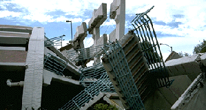
Case Study: Data Mining the Northridge Earthquake
The data collected during the Northridge, California earthquake occupied several warehouses, and ranged from magnetic media to bound copies of printed reports. Nautilus Systems personnel sorted, organized, and cataloged the materials. Document were scanned and converted to text. Data were organized chronologically and according to situation reports, raw data, agency data, and agency reports. For example, the Department of Transportation had information on highways, street structures, airport structures, and related damage assessments.
 Nautilus Systems applied its proprietary data mining techniques to extract and refine data. Geography was used to link related information, and text searches were used to group information tagged with specific names (e.g., Oakland Bay Bridge, San Mateo, Marina). The refined data were further analyzed to detect patterns, trends, associations and factors not readily apparent. At that time, there was not a seismographic timeline, but it was possible to map the disaster track to analyze the migration of damage based upon geographic location. Many types of analyses were done. For example, the severity of damage was analyzed according to type of physical structure, pre- versus post- 1970 earthquake building codes, and off track versus on track damage. It was clear that the earthquake building codes limited the degree of damage. Nautilus Systems applied its proprietary data mining techniques to extract and refine data. Geography was used to link related information, and text searches were used to group information tagged with specific names (e.g., Oakland Bay Bridge, San Mateo, Marina). The refined data were further analyzed to detect patterns, trends, associations and factors not readily apparent. At that time, there was not a seismographic timeline, but it was possible to map the disaster track to analyze the migration of damage based upon geographic location. Many types of analyses were done. For example, the severity of damage was analyzed according to type of physical structure, pre- versus post- 1970 earthquake building codes, and off track versus on track damage. It was clear that the earthquake building codes limited the degree of damage.
Nautilus Systems also looked at the data coming into the command and control center. The volume of data was so great that a lot was filtered out before it got to the decision support level. This demonstrated the need for a management system to build intermediate decision blocks and communicate the information where it was needed. Much of the information needed was also geographic in nature. There was no ability to generate accurate maps for response personnel, both route maps including blocked streets and maps defining disaster boundaries. There were no interoperable communications between local police, the fire department, utility companies, and the disaster field office. There were also no predefined rules of engagement between FEMA and local resources, resulting in delayed response (including such critical areas as firefighting)
Benefits
Nautilus Systems identified recurring data elements, data relationships and metadata, and assisted in the construction of the Emergency Information Management System (EIMS). The EIMS facilitates rapid building and maintenance of disaster operations plans, and provides consistent, integrated command (decision support), control (logistics management), and communication (information dissemination) throughout all phases of disaster management. Its remote GIS capability provides the ability to support multiple disasters with a central GIS team, conserving scarce resources.
[ Home |
News |
About Nautilus |
Case Studies |
Partners |
Contact Nautilus ]
|